Trail Mountain bike Les Monts-d'Andaine - Au fil des chemins à VTT Andaines et Domfrontais - Circuit n°16 - La Gione - Photo

Au fil des chemins à VTT Andaines et Domfrontais - Circuit n°16 - La Gione

 tracegps
tracegps

User

© OpenStreetMap contributors
Length
Length
25 km
Max alt
Max alt
290 m
Uphill gradient
Uphill gradient
370 m
Km-Effort
Km-Effort  
30 km
Min alt
Min alt
170 m
Downhill gradient
Downhill gradient
370 m
Boucle
Boucle
Yes
Creation date :
2014-12-10 00:00:00.0
Updated on :
2014-12-10 00:00:00.0

(0 Reviews)

Mountain bike
Mountain bike
2h15
Difficulty : Medium

Scan this QR Code to open this trail in the SityTrail application

FREE GPS app for hiking

Logo SityTrail SityTrail

IGN / Geographical institutes

Download SityTrail from the App Store Download SityTrail from Google Play

Logo SityTrail SityTrail World

The world is yours!

Download SityTrail from the App Store Download SityTrail from Google Play Download SityTrail on Huawei AppGallery

About

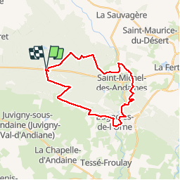
Trail Mountain bike of 25 km to be discovered at Normandy, Orne, Les Monts-d'Andaine. This trail is proposed by tracegps.

Description

Un des nombreux parcours balisés dans la forêt d'Andaines. Mélange de piste forestière et de sentiers. Très agréable et pas difficile. En plus, le passage à Bagnoles de l'Orne peut être l'occasion de boire un coup ou tout simplement de faire une petite pause. La partie entre Bagnoles de l'Orne et la croix d'Andaines est un peu plus sauvage sur des sentiers plus étroits mais bien tracés.

Elevation profile

Positioning

Country:
France
Region :
Normandy
Department/Province :
Orne
Municipality :
Les Monts-d'Andaine
Location:
La Sauvagère
Start:(UTM)
685151 ; 5384723 (30U) N.

Trails nearby

Trail Walking Bagnoles-de-l'Orne-Normandie - Bagnoles de l' orne - Photo
Walking
MichelRando7656

Walking

Very easy
Bagnoles-de-l'Orne-Normandie, Normandy, Orne, France
4.8 km | 6.1 km-effort
1h 49min
Yes
Trail Mountain bike  - Espace VTT FFC les Ecureuils du Domfrontais - Circuit n°14 - Champsecret - Photo
Mountain bike
tracegps

Mountain bike

Medium
, Normandy, Orne, France
22 km | 26 km-effort
2h 0min
Yes
Trail Walking Bagnoles-de-l'Orne-Normandie - Bagnoles-de-l'Orne - Couterne - Photo
Walking
mrcat

Walking

Difficult
Bagnoles-de-l'Orne-Normandie, Normandy, Orne, France
19.1 km | 23 km-effort
4h 0min
Yes
Trail Walking Juvigny-Val-d'Andaine - Église st Geneviève  - Photo
Walking
Elisabeth Neveu

Walking

Very easy
Juvigny-Val-d'Andaine, Normandy, Orne, France
5.5 km | 6.9 km-effort
1h 43min
Yes
Trail Walking Bagnoles-de-l'Orne-Normandie - reco du 24 19 - Photo
Walking
toporient

Walking

Very easy
Bagnoles-de-l'Orne-Normandie, Normandy, Orne, France
64 km | 76 km-effort
2h 29min
Yes
Trail Walking Dompierre - Dompierre; trace GPS du 10/09/2019 - Photo
Walking
toporient

Walking

Very easy
Dompierre, Normandy, Orne, France
8.2 km | 10.2 km-effort
4h 30min
Yes
Trail Walking Dompierre - Dompierre longue - Photo
Walking
toporient

Walking

Medium
Dompierre, Normandy, Orne, France
8.3 km | 10 km-effort
2h 13min
Yes
Trail Walking Bagnoles-de-l'Orne-Normandie - La Grande Houssaye - Photo
Walking
toporient

Walking

Easy
Bagnoles-de-l'Orne-Normandie, Normandy, Orne, France
8 km | 9.6 km-effort
2h 4min
Yes
Trail Walking Champsecret - Ermitage-Roches aux Dames et aux loups - Photo
Walking
toporient

Walking

Medium
Champsecret, Normandy, Orne, France
9 km | 11 km-effort
2h 23min
Yes


Close
My subscriptions